

Habitat and Land Cover Change Detection in Alpine Protected Areas: A Comparison of AI Architectures
Paper • 2511.00073 • Published
image image |
|---|
HabitAlp2.0 is an ecological habitat mapping dataset for the Gesäuse National Park and Natura 2000 area in Austria, covering approx. 154 km². It includes 30,241 polygons annotated via aerial photo stereo-interpretation for the years 1954, 2003, and 2013. Remote sensing layers are included to support AI-driven habitat classification and change-detection tasks.
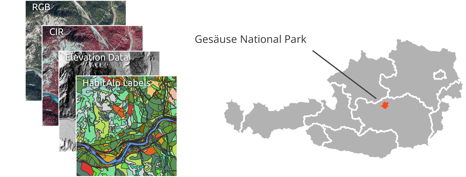
Ground truth labels are provided in raster format (GeoTIFF, 0.2 m, EPSG:32633) for each year and in vector format (GeoPackage).
| File | Content |
|---|---|
labels/classes_2003.tif, classes_2013.tif, classes_2020.tif |
23-class habitat labels per year (0 = no data) |
labels/classes_2013_test_cells.tif |
2013 labels restricted to the test cells of the spatial split (12 × 12 grid, 15 % test) |
labels/habitalp_change_2003_2013.tif, habitalp_change_2013_2020.tif |
change maps with nine transition classes (255 = no data) |
labels/habitalp_classes.gpkg |
polygons for 1954, 2003 and 2013 |
labels/habitalp_classes_2020.gpkg |
polygons for 2020 (four LiDAR-covered test patches) |
labels/classes_description.csv |
class table with source habitat codes |
Habitat polygon records in habitalp_classes.gpkg are organized by acquisition year, with column labels named using a prefix letter:
habitalp_classes_2020.gpkg uses the prefix D for 2020. The 2020 interpretation started from the 2013 polygons and split them where a change affected only part of a polygon, so OBJECTID refers to the 2013 parent polygon and ID_2020 identifies each 2020 polygon.
The change maps follow the transition rules in get_change_array of the code repository (src/trainers/utils.py).
Remote sensing sources include orthophotos and LiDAR elevation data.
| ID | Class Name (CC = canopy cover in %) | Area 2013 (ha) | Total area share 2013 (%) |
|---|---|---|---|
| 1 | Waterbody | 95.3 | 0.62 |
| 2 | Gravel bank, shoal, fluviatile | 17.2 | 0.11 |
| 3 | Erosion area, gully | 447.3 | 2.93 |
| 4 | Debris-covered areas | 594.7 | 3.90 |
| 5 | Rock | 2632.8 | 17.26 |
| 6 | Young coniferous (growth, thicket) | 439.8 | 2.88 |
| 7 | Young broad-leaved (growth, thicket) | 206.1 | 1.35 |
| 8 | Coniferous pole timber CC<80 | 239.0 | 1.57 |
| 9 | Coniferous pole timber CC>=80 | 787.6 | 5.16 |
| 10 | Broad-leaved pole timber | 161.3 | 1.06 |
| 11 | Coniferous mature forest CC<80 | 1010.7 | 6.63 |
| 12 | Coniferous mature forest CC>=80 | 1667.1 | 10.93 |
| 13 | Broad-leaved mature forest CC<80 | 97.0 | 0.64 |
| 14 | Broad-leaved mature forest CC>=80 | 539.3 | 3.54 |
| 15 | Old coniferous forest, multilayered CC<80 | 969.0 | 6.35 |
| 16 | Old coniferous forest, multilayered CC>=80 | 695.8 | 4.56 |
| 17 | Old broad-leaved forest, multilayered CC<80 | 77.9 | 0.51 |
| 18 | Old broad-leaved forest, multilayered CC>=80 | 439.8 | 2.88 |
| 19 | Clearcut areas | 224.1 | 1.47 |
| 20 | Mountain dwarf forest ('Krummholz' belt) | 2225.5 | 14.59 |
| 21 | Grassland, buffer strip between forest/open land | 462.7 | 3.03 |
| 22 | Alpine grassland, heath | 1095.7 | 7.18 |
| 23 | All other classes/areas of low importance and/or small extent | 130.3 | 0.85 |
v4 (current). Canopy cover (CC<80 vs CC>=80) of the pole timber, mature and old forest classes is derived from airborne LiDAR: the 2010/11 LiDAR canopy cover for 2013 and the 2020 LiDAR for 2020. This replaces the canopy cover estimated by the interpreters, following feedback from Gesäuse National Park. Clearcut polygons in 2013 whose LiDAR canopy cover was still at least 40 % (cut after the LiDAR acquisition) are set to no data (510 polygons, 141.6 ha; C_Class = "Deviation LIDAR and Habitalp 2013", C_Class_ID = 0). The 2013 and 2020 labels, the 2013–2020 change map and the class table were updated; the 2013 test-cell mask and the 2020 polygons were added. The 2003 labels and the 2003–2013 change map are unchanged from v3 (no LiDAR for 2003), so the 2003–2013 change map is based on the v3 2013 labels.
v3 (git tag v3). Canopy cover from the interpreters' estimate. This is the version used in the pre-print (arXiv:2511.00073). Load it with revision="v3".
The curation of the original Habitalp Dataset by Gesäuse National Park was funded by the Austrian Program for Rural Development 2014-2020 (LE): Projekt 761A/2015/51 „Natura 2000 Management & Monitorings“